Whether it’s figuring out which freeway exit to take or discovering a new country to visit, maps allow people to better maneuver the world around them. And, while no one should use a fifteenth century map to navigate their modern day ocean voyage, old maps built the foundation of this world knowledge geographically, politically and religiously. Some old maps show the resilience of the cartographer, who did what they could with the resources available. Others show a desire for imperial power. Some even forgo geographic accuracy in favor of religious teaching. Explore the list below to discover the world of ancient and medieval maps in their many forms.
12. Great Universal Geographic Map
Year: 1602 (earliest versions were in 1584, but have been lost)
Cartographer: Matteo Ricci
Place of Origin: China
Level of Accuracy: Somewhat accurate because the design of the continents is surprisingly similar to modern maps.
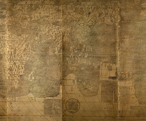 photo source: World Digital Library
Matteo Ricci, an Italian missionary living in China, made the 1602 Great Universal Geographic map at the request of Li Zhizao, a friend and cartographer. Originally, Ricci had a European map displayed in his home in the hopes of impressing his Chinese visitors with the scholarly efforts of Christian Europe. Whether or not the map converted people is up for debate, but it definitely left an impression. In 1584, the visitors asked Ricci to translate the document into Chinese since it showed places not yet familiar to them. Zhizao asked for an updated version of this map in 1602, which is the only version around today. The map includes Africa, Europe, Asia and the Americas, along with notes about those places. It is the oldest known Chinese map to depict the Americas.
11. Cantino Planisphere
Year: 1502
Cartographer: Unknown, but stolen by Alberto Cantino
Place of Origin: Portugal
Level of Accuracy: Low as its contents became less relevant with more trips to America.
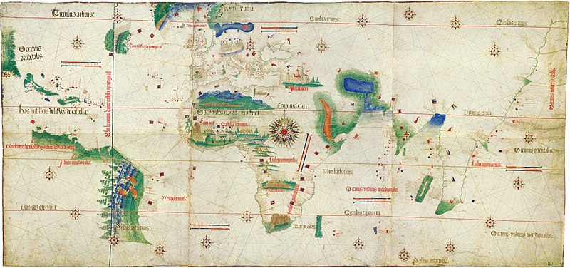 photo source: Wikimedia Commons
Before the “Age of Exploration” and its subsequent imperialism and plundering, maps served as a scholarly tool of interest that aided in travel. After this age began, maps became more accurate and, therefore, more valuable. Leaders could send ships out to “new” territories to uncover riches and conquer inhabitants. The Cantino Planisphere resulted from a need to get ahead and a bit of espionage. The map contained secret Portuguese trade routes and geographic discoveries, including Brazil’s coastline, that were integral to the country’s role in the Americas. An undercover agent named Alberto Cantino obtained the map and gave it to the Italian duke who employed him. The map included depictions of Latin America, important landmarks, and the trade routes of other explorers, including Christopher Columbus.
10. Henricus Martellus World Map
Year: 1490
Cartographer: Henricus Martellus
Place of Origin: Italy
Level of Accuracy: Low, but more accurate than Ptolemy’s map.
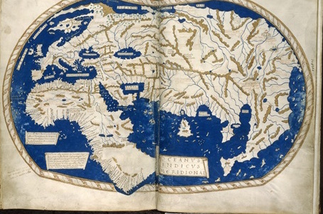 photo source: British Library
Ptolemy’s map reigned supreme throughout the medieval cartographic world for a long time. However, as more European explorers/ conquerors went off to survey new regions, Ptolemy’s map model came into question. Martellus’ world map demonstrates this break from Ptolemy. Although Martellus kept Ptolemy’s basic structure, he made clear changes to the design of Africa, a result of Bartolomeu Dias’ trip around the Cape.
9. T-O Map
Year: 1472
Cartographer: Isidore, Bishop of Seville
Place of Origin: Spain
Level of Accuracy: Low. The only accurate part is that Asia, Europe and Africa are all places that exist.
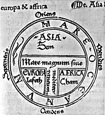 photo source: Princeton University
T-O maps do not describe a singular document, but a medieval map-making trend. The maps appeared as the letter “T” inside of an “O”— hence, the name. The T shape divided the three known continents: Asia, Africa and Europe. Asia held particular significance as medieval cartographers saw it as the location of the Garden of Eden as well as Jesus Christ’s birthplace. The O shape represented the surrounding ocean. The T-O map referenced here is the earliest example of a printed T-O map, although the trend might have begun much earlier.
8. Leardo’s Mappa Mundi
Year: 1452
Cartographer: Giovanni Leardo
Place of Origin: Italy
Level of Accuracy: Mostly low as it does not include all of the continents but does have some accurate oceans.
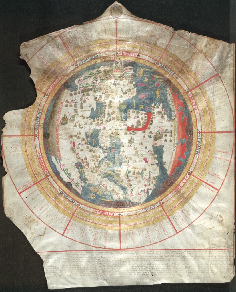 photo source: American Geographical Society Library
Leardo’s Mappa Mundi is regarded as an ideal example of medieval maps. Like other maps at the time, it places Jerusalem at the center— indicating Europe’s overwhelmingly Christian leanings. The rest of the map consists of Europe, Africa and Asia. Asia rests at the top while Europe is on the left and Africa on the right. Leardo relied on Ptolemy’s naming system from “Geographia” and Marco Polo’s travel accounts to create his Mappa Mundi. The depiction of the seas is fairly accurate due to the use of sea charts. Leardo marked some southward lands as uninhabitable due to heat and some northern ones as uninhabitable due to cold.
7. Ptolemy’s Map of the World
Year: 1407
Cartographer: Ptolemy
Place of Origin: Egypt
Level of Accuracy: Low because it does not include every continent and is based on inaccurate math.
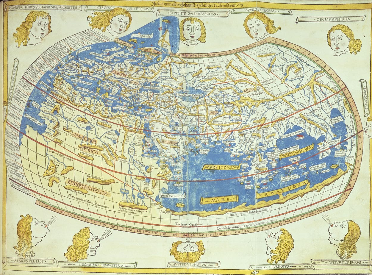 photo source: British Library
Ptolemy’s map was based on years of research from the acclaimed mathematician, geographer and astronomer. He originally wrote the coordinates in a book entitled “Geographia.” These coordinates were important because they changed how cartographers designed maps. Prior to Ptolemy’s contribution, cartographers based countries’ sizes on their significance— places deemed important were made larger. Ptolemy, however, used mathematics to attempt to accurately determine the size of various land masses. While his calculations were generally incorrect, it was a step in the right direction. The map included distorted versions of Africa, Asia, Europe and the Middle East. The Americas, however, had yet to make an appearance.
6. The Da Ming Hunyi Tu
Year: c. 1400
Cartographer: Unknown
Place of Origin: China
Level of Accuracy: Low with certain places depicted better than others.
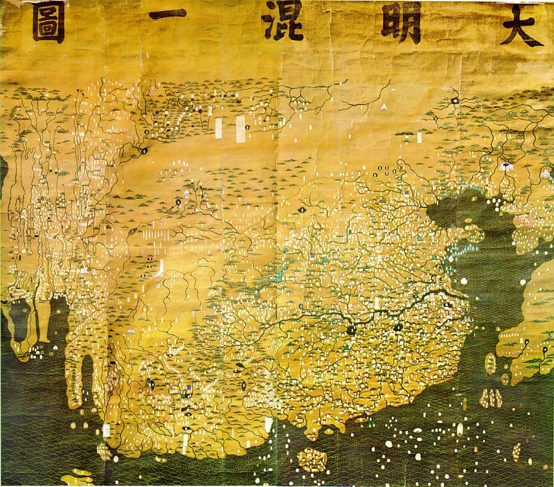 photo source: Wikimedia Commons – Public Domain
The Da Ming Hunyi Tu is the earliest known map of the world to show the entire African continent. Today, the map faces some scrutiny for its political role as well as its true origins. Many historians believe that the references on the map date back to before the fifteenth century and borrow from research done outside of China. The depiction of Africa is fairly accurate while other areas vary in reliability. Europe, in particular, is much less detailed than China or Africa.
5. Vesconte’s World Map
Year: 1311
Cartographer: Pietro Vesconte
Place of Origin: Italy
Level of Accuracy: Low, but had some accurate features like the depictions of the Mediterrean and the Black Sea.
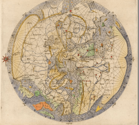 photo source: Standford.edu Creative Commons Attribution-Noncommercial-Share Alike 3.0 Unported License
Pietro Vesconte’s world map is circular with Jerusalem at the center (as is typical of medieval cartography). It features Africa, Europe and Asia with particular attention given to shorelines familiar to Italian traders and travelers. While many aspects of the map are characteristic of inaccurate medieval trends, it has fairly accurate depictions of the Mediterrean and the Black Sea. The appearances of Norway and Scandinavia are also notable as they did not often appear in medieval maps. The image seen here is a 1611 reprint of Vesconte’s map.
4. Tabula Rogeriana
Year: 1154
Cartographer: al-Idrisi
Place of Origin: Italy
Level of Accuracy: Low, but relied on lots of research and calculated the earth’s circumference within 10 percent accuracy.
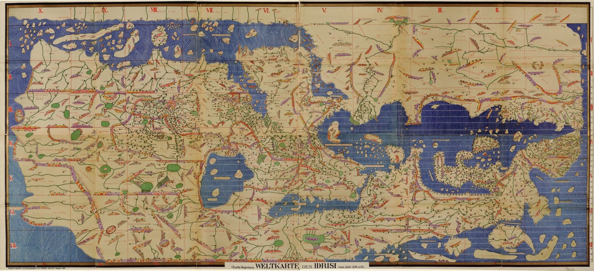 photo source: Library of Congress
The Tabula Rogeriana is book of maps by Muslim North Afirican cartographer al-Idrisi. It covers the world from Iceland to China. Al-Idrisi consulted geographic works from Latin, Arabic and Classic origins and interviewed travelers to write and illustrate his book. The Tabula Rogeriana depicts a spherical world and, although lost to time, al-Idrisi also used his knowledge to create a globe. He even calculated the earth’s circumference within 10 percent of the real number.
3. Osma Beatus Map
Year: 1086
Cartographer: Unknown Spanish monk
Place of Origin: Spain
Level of Accuracy: Low as it was meant to teach about Christianity, not accurately depict the world.
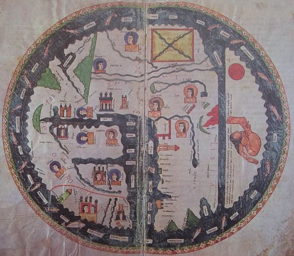 photo source: Medievalist.net
The Osma Beatus Map is part of a series of maps called the Beatus of Liébana by a Spanish monk. These maps represent a trend in medieval map making that tended toward religious teachings over accurate/reliable constructions of the world. These “Christian maps of the world” usually depicted the locations of various biblical events. The Osma Beatus, in particular, showed the apocalypse of St. John.
2. Madaba Mosaic Map
Year: 500
Cartographer: Unknown
Place of Origin: Jordan
Level of Accuracy: Low but somewhat accurate in its depiction of specific landmarks and locations.
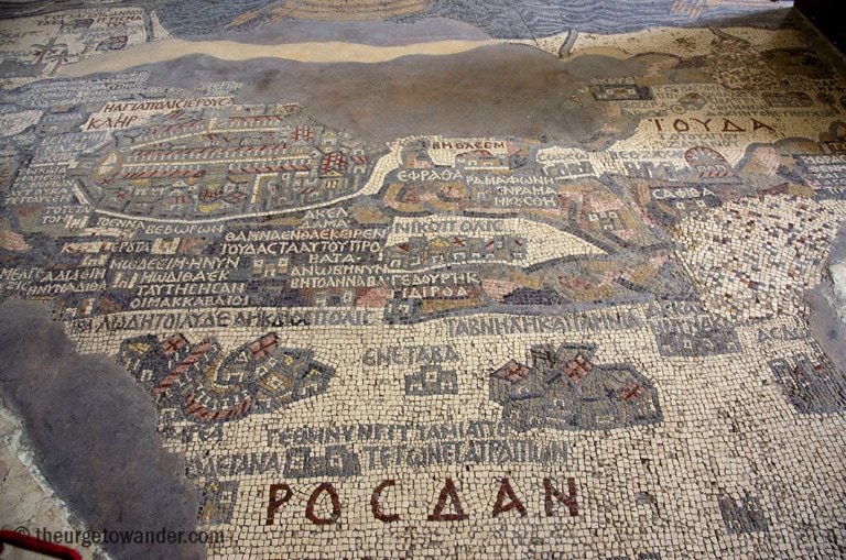 photo source: theurgetowander.com
As with many old world maps, the term “world” is flexible. Known as the oldest geographic floor mosaic on record, the Madaba Mosaic map shows cities and locations from the Nile Delta to Lebanon during the Byzantine Empire. Other areas could have also been included, but have been lost to time. Additionally, as is evident with other maps, the city of Jerusalem is particularly impressive on the mosaic. The artists included several landmarks throughout Jerusalem in relatively accurate detail.
1. Imago Mundi
Year: 400 BCE
Cartographer: Unknown
Place of Origin: Modern day Iraq
Level of Accuracy: Low as it depicted a small part of the world and included mythical places.
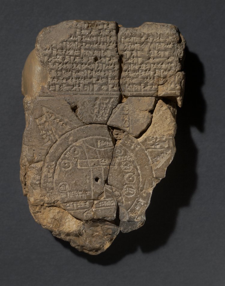 photo source: British Museum under creative commons CC BY-NC-SA 4.0 license
The Imago Mundi is the oldest surviving map in the world. Created in the ancient city of Babylon in the fifth century BCE, it depicts the world as the ancient Babylonians saw it on a clay tablet with cuneiform and cartographical etchings. Since the creator(s) of the Imago Mundi did not have the same access to exploratory methods as successive generations, the map is not a reliable geographic source. Historians posit that it shows a mix of nearby and known regions as well as mythical ones.